Published 21 Feb 2024
Article by
4 min read
What is a Flood Risk Assessment?
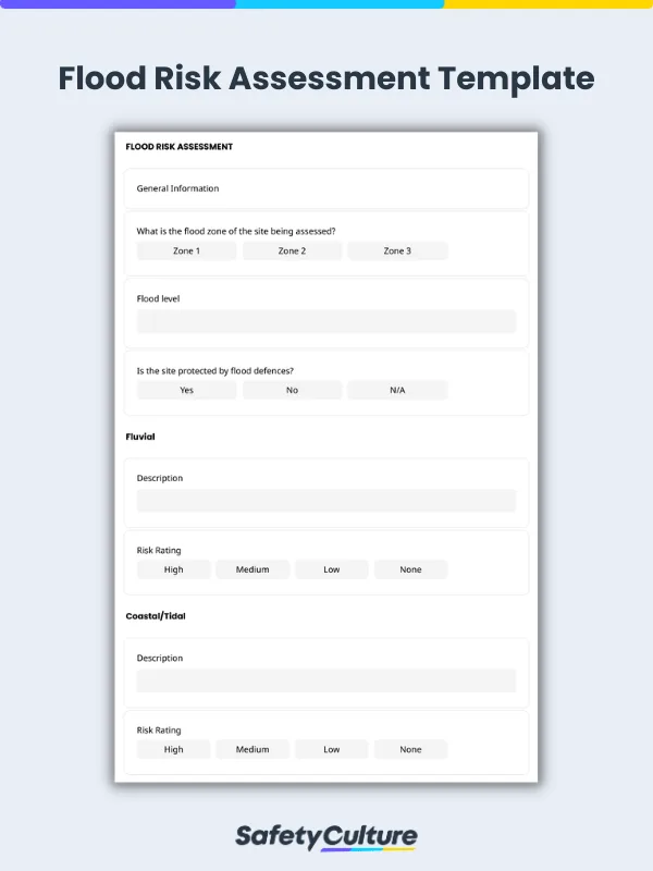
A Flood Risk Assessment (FRA) is a systematic process which aims to identify the sources and level of flood risks of a property or site. The UK Environment Agency requires property investors and developers to complete an FRA prior to development within key flood zones.
What are Flood Hazards?
Flood hazards are hazards associated with flooding. It is divided into: primary, secondary, and tertiary. Primary hazards are those that are caused by direct contact with flood waters. Secondary hazards are those caused by the flooding. While, tertiary hazards are the long term changes that occur due to the flooding.
Below is a table showing flood hazards grouped by their effects:
Primary | Secondary | Tertiary |
Transport of large particles or objects such as automobiles, houses, and bridges caused by high water velocities | Disruption of services (e.g., gas and electrical service, water, and transportation systems) | Change in location of river channels due to flooding. New channels may develop, leaving old channels to dry out |
Massive amounts of erosion caused by flood waters | Health hazards such as famine and diseases | Farm lands destroyed caused by deposited sediments carried by flood waters |
Water damage on human built structures | Job loss due to disruption of services, destruction of business | |
Flood waters carrying more sediment as suspended load resulting to the deposit of sediment to flooded area once flood waters retreat | Increase of insurance rates | |
Crop loss, and carried away or drowning of livestock, pets, and other animals | Corruption resulting from misuse of relief funds | |
Humans carried away or drowned by the flood water | Destruction of wildlife habitat | |
Concentration of garbage, debris, and toxic pollutants through flood waters |
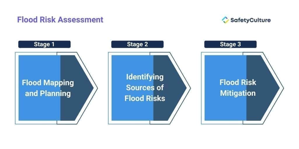
Stages of Flood Risk Assessment
Completing a flood risk assessment involves a systematic process before proceeding with any major decision. Here are the three essential stages in conducting a comprehensive flood risk assessment:
Flood Risk Assessment
Stage 1: Flood Mapping and Planning
Once you have identified that you are within a medium to high probability flood zone you will begin with the planning and preliminary assessment stage. This stage includes detailed mapping of the proposed development site with a focus on areas at risk of flooding. It also involves a review of floods that have taken place and floods that could take place in future.
Stage 2: Identifying Sources of Flood Risks
The most essential part of completing an FRA is to determine the vulnerability of the site or property from any flood occurrences. Flood risks can be both natural or artificial.
Here are 8 major sources of flood risks to look out for during flood assessments:
– also known as river flooding, this occurs when a nearby river or stream was not able to take on water causing an overflow above its banks down to the mainland.
– this occurs due to bad weather conditions such as high tides, storms and surges which rises sea water levels.
– flooding occurs when canals are impounded above surrounding ground levels and when retaining structure fails.
– this occurs when the water table rises above ground elevations and usually after a long period of continuous rains.
– large water bodies or reservoirs are used to retain water in times of flood. However reservoirs and water bodies could overtop which can lead to rapid outpouring of water to floodplains.
– a gradual flooding of low-lying areas after prolonged and intense rains. This happens when soil infiltration and drainage infrastructure capacities are overwhelmed and inadequate.
– sewer flooding are due to excessive flows or blockage in the infrastructure such as manholes and gullies, which can also generate overland flows.
– catchments or watersheds are areas of land where a river or lake collects water from rain. Development with catchments can increase flows into sewer networks.
Stage 3: Flood Risk Mitigation
The final stage of an FRA is to set out mitigation measures to address and reduce flooding risks within acceptable levels. This includes installation of flood defenses to control potential negative effects of flood waters, managing residual risks, and improving water systems and infrastructure.
What is a Flood Report?
A flood report, or a flood risk assessment report, is a comprehensive document that details a proposed development site’s risk of flooding. Flood risk assessment reports are used by local planning authorities, property investors, and developers to understand the potential of a flood with a particular intensity will occur over an extended period of time. A flood risk assessment report can reveal how flood risks can be controlled, proper urban planning can be employed, and quality of life can be improved.

Still looking for a checklist?
Search, filter, and customize 60,000+ templates across industries and use cases.